Price: $3,500.00
SKU: 34440
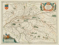
ARTIST: Joan Blaeu
MEDIUM: Copper plate engraving,
DATE: 1647
EDITION SIZE: Image size 16 3/8 x 17 1/2" (415 x 445 mm) plus margins.
DESCRIPTION: A fine map of the Brazilian coast shown from Rio San Francisco to Rio Gujaraigacu. This is one the first maps of Brazil based on Dutch rather than Portuguese interest. The Dutch West India Company, appointed Count Johan Maurits Governor-General of Dutch Brazil in 1636, he remained in power until 1644. Upon Maurits return to Europe, he commissioned Kaspar van Baerle to document the flora and fauna, climate, inhabitants, religion, and languages of the coastal provinces of Brazil The resulting work was "Rerum per octennium in Brasilia." This work was published by Blaeu in 1647 and is one of the finest early descriptions of Brazil ever produced. The maps in this work, with alterations, also appeared in editions Blaeu's "Atlas Major." This detailed map is highly embellished with a cartouche, a sea monster and numerous galleons under sail. Below the cartouche is a scene of local inhabitants fishing using a lookout tower and a seine net.
ADDITIONAL INFO:
CONDITION: Good condition. Original hand coloring.
REFERENCE:


 Login / Register
 Basket