Price: $2,500.00
SKU: 36130
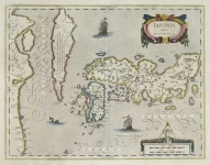
ARTIST: Joannes Jansson
MEDIUM: Copper plate engraving,
DATE: 1650.
EDITION SIZE: Image size 16 1/8 x 20 3/4" (41.1 x 52.9 cm).
DESCRIPTION: This beautiful sea chart by Jansson shows Hispaniola, Cuba, Jamaica, the Bahamas, and the southern half of Florida. Florida is shown with unusual mountain ranges. The chart is richly ornamented with a compass rose, Galleons and rhumb lines. The title cartouche depicts two native children holding up a cowhide, which was one of Hispaniola's main exports at the time. At their feet are tropical fruits. The scale is richly embellished with fish, eels and aquatic putti. This chart appeared in Janson's "Atlas Novus." Cartographically, this map was based on the extremely rare Hesseel Gerritsz sea chart of c.1631.
ADDITIONAL INFO:
CONDITION: Good condition save for some damp staining in the lower margin. Original outline hand coloring
REFERENCE: #291 in "The Mapping of North America" by Philip Burden.


 Login / Register
 Basket