Price: $300.00
SKU: 36473
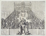
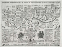
ARTIST: Henri Chatelain
PUBLISHER: Published in Amsterdam by L’Honore & Chatelain.
MEDIUM: Copper plate engraving printed on fine laid paper,
DATE: 1714
EDITION SIZE: 15 1/2 x 18 3/8" (394 x 467 mm) plus margins.
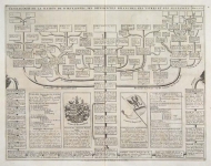
DESCRIPTION: This impressive map is the seventh plate in volume four of Chatelain’s celebrated encyclopedia, Atlas Historique. Printed in 1714, this unique engraving is from the first edition of volume four published by Chatelain as part of his large seven volume work. This is a lovely impression of Chatelain’s large map of Lapland. The map covers all of northern Sweden and part of northern Finland. It includes most of northern Norway and the northern section of the Russian border. Great attention has been paid to the geographical features of the area as well as the many waterways and mountains scattered across the terrain. The extensive key table identifies the various duchies and provides a list of the major lakes and rivers. By combining a wealth of historical and geographical information with delicate engraving and an uncomplicated composition, this elegant map is a superb example from the golden age of French mapmaking.
ADDITIONAL INFO:
CONDITION: Very good condition. Black and white.
REFERENCE: Phillips, A List of Geographical Atlases in the Library of Congress, 305, 548, & 579; Moreland & Bannister, Antique Maps; Koeman, Atlantes Neerlandici, vol. II. p. 33-38.


 Login / Register
 Basket