Price: $400.00
SKU: 36477
ARTIST: Henri Chatelain
PUBLISHER: Published in Amsterdam by L’Honore & Chatelain.
MEDIUM: Copper plate engraving printed on fine laid paper,
DATE: 1714
EDITION SIZE: 19 5/8 x 23 1/2" (498 x 598 mm) plus margins.
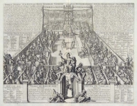
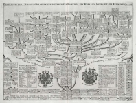
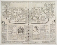
DESCRIPTION: This impressive engraving is the third plate in volume four of Chatelain’s celebrated encyclopedia, Atlas Historique. Printed in 1714, this unique map is from the first edition of volume four published by Chatelain as part of his large seven volume work. This is a lovely impression of Chatelain’s large fold out map of Denmark. The map covers all of Denmark as well as the isle of Fyn (Isle de Fyonie) and Sjaelland (Isle de Selande). The southern tip of Sweden is also included stretching as far north as Gotland, and the northern coast of Germany is also shown extending to Rugen. The Baltic, Skaggerak, and North seas are all clearly identified, and great attention has been paid to the geographical features of the area. The many waterways and mountains have all been meticulously marked and the areas of shallow water have also been depicted. Two detailed key tables are included on either side of the map identifying the principal towns and different states. By combining a wealth of historical and geographical information with delicate engraving and an uncomplicated composition, this elegant map is a superb example from the golden age of French mapmaking.
ADDITIONAL INFO:
CONDITION: Very good condition. Creases in sheet where it has been folded to fit into atlas. Black and white.
REFERENCE: Phillips, A List of Geographical Atlases in the Library of Congress, 305, 548, & 579; Moreland & Bannister, Antique Maps; Koeman, Atlantes Neerlandici, vol. II. p. 33-38.


 Login / Register
 Basket