Price: $65.00
SKU: 36619
ARTIST: Henri Chatelain
PUBLISHER: Published in Amsterdam by L’Honore & Chatelain.
MEDIUM: Copper plate engraving printed on fine laid paper,
DATE: 1721
EDITION SIZE: 13 1/4 x 17 1/2" (337 x 445 mm) plus wide margins.
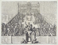
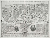
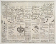
DESCRIPTION: This impressive plate is a wonderful example of Chatelain’s elegant engravings. Included in the 1721 edition of Atlas Historique, published by Chatelain in Amsterdam, this large sheet is the thirty-sixth illustration in volume one. Illustrated with numerous vignettes this decorative plate provides a detailed description of the infrastructure of the Spanish government. The plate is adorned with a set of finely drawn images depicting the various offices of government. Highly decorative, this impressive engraving provides a wealth of information in a meticulous yet beautiful manner, and is a wonderful example of Chatelain’s superior engravings.
ADDITIONAL INFO:
CONDITION: Fair condition. Black and white.
REFERENCE: Phillips, A List of Geographical Atlases in the Library of Congress, 305, 548, & 579; Moreland & Bannister, Antique Maps; Koeman, Atlantes Neerlandici, vol. II. p. 33-38.


 Login / Register
 Basket