Price: $5,250.00
SKU: 3546
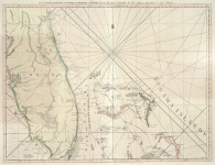
ARTIST: Thomas Jefferys
PUBLISHER: London, printed for Robt. Sayer, Map and printseller, No. 53 Fleet Street.
MEDIUM: Copper plate engraving,
DATE: Feb. 20, 1775.
EDITION SIZE: Two sheets joined to form one, 18 5/8 x 59 1/4" (47.6 x 123.8 cm).
DESCRIPTION: A beautiful chart of Florida and the Bahamas that was produced during the last third of the eighteenth century. This map is drawn on a large scale, over four feet across, and is finely engraved and includes detailed coastal information, soundings and historical notes. This map appeared in Thomas Jefferys' "The American Atlas: or A Geographical Description of the Whole Continent of America..."
ADDITIONAL INFO:
CONDITION: Good condition save for some repaired splitting along fold lines. Backed on rice paper. Full hand coloring.
REFERENCE: Stevens & Tree #26, state b.


 Login / Register
 Basket