Price: $425.00
SKU: 38789
ARTIST: James Imray
PUBLISHER: London Published by James Imray & Son, 89 & 102 Minories.
MEDIUM: Engraving.
DATE: 1878
EDITION SIZE: 33 1/2 x 48 1/2" plus margins.
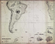
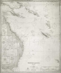
DESCRIPTION: A scarce, large scale two-sheet, blue-backed chart. This chart depicts the River Plate. There are five inset charts, Buenos Ayres Roads (includes good detail of the city); Colonia Roads; Monte Video; Maldonado Bay; and Lobos Island. Working sea charts are inherently rare due to the nature of their use aboard ships. Although likely common when first made, the vast majority of them were either destroyed by use or destroyed intentionally when new updated versions were obtained. We have no records of ever seeing this chart before. James Imray, 1803-1870. Imray originally was in the stationary and account book publishing business. In 1836 Imray joined with Michael Blachford, a small sea chart publisher based in London. The partnership flourished and soon began to compete with the larger firm of Norie and Wilson. In 1846 Imray bought out Blachford, taking over as sole proprietor. The firm later, led by descendents, survived into the 20th century.
ADDITIONAL INFO:
CONDITION: Some surface soiling and occasional minor tears. Three vertical creases. Overall good condition for a sea chart of the period. Light houses and light ships colored, otherwise uncolored.
REFERENCE:


 Login / Register
 Basket