Price: $275.00
SKU: 38790
ARTIST: James Imray
PUBLISHER: London Published by James Imray & Son, 89 & 102 Minories.
MEDIUM: Engraving
DATE: 1884
EDITION SIZE: 40 x 49 3/4" plus margins.
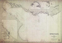
DESCRIPTION: A scarce large scale, two-sheet, blue-backed chart. This chart depicts the whole of the South Atlantic Ocean including part of the South Shetland Islands. There are nine inset plans, they are The Rocas; Ascension Island, St. Helena Island; Martin Vaz Islets; Trinidad Island; St. Paul Rocks; Anchorage of Gouge Isle; Fernando Noronha; and Tristan da Cunha. Working sea charts are inherently rare due to the nature of their use aboard ships. Although likely common when first made, the vast majority of them were either destroyed by use or destroyed intentionally when new updated versions were obtained. We have no records of ever seeing this chart before. James Imray, 1803-1870. Imray originally was in the stationary and account book publishing business. In 1836 Imray joined with Michael Blachford, a small sea chart publisher based in London. The partnership flourished and soon began to compete with the larger firm of Norie and Wilson. In 1846 Imray bought out Blachford, taking over as sole proprietor. The firm later, led by descendents, survived into the 20th century.
ADDITIONAL INFO:
CONDITION: Some surface soiling and occasional minor tears along sheet edges. Overall good condition for a sea chart of the period. small loss in lower left corner. Black & white.
REFERENCE:


 Login / Register
 Basket