Price: $425.00
SKU: 47149
ARTIST: Fielding Lucas, Jr.
PUBLISHER: Published by Carey & Lea, Philadelphia.
MEDIUM: Handcolored copper plate engraving,
DATE: c.1822.
EDITION SIZE: 16 1/2 x 20 1/2" (420 x 518 mm) including text, plus margins.
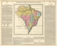
DESCRIPTION: This map, "Geographical, Statistical, and Historical Map of the Leeward Islands", by Fielding Lucas, Jr., 1822. Engraved by J. Yeager, this finely detailed map was published in Philadelphia as part of Carey & Lea’s celebrated A Complete Historical, Chronological, and Geographical American Atlas. It presents a sweeping view of the Leeward Islands in the eastern Caribbean, including Anguilla, St. Martin, St. Bartolomew, Saba, Barbuda, St. Eustatia, St. Christopher’s (St. Kitts), Nevis, Antigua, Montserrat, Redonda, Guadeloupe, the Saintes, Désirade, Marie-Galante, and Dominica. Each island is crisply rendered, with finely engraved coastlines and thoughtful labeling—ideal for study or display. What sets this map apart is its informative and engaging text panel, which offers geographical descriptions, population statistics, and a “historical sketch” for each island. Lucas, a pioneering American map publisher, was known for bringing clarity and context to his work, and this map is no exception. Produced during a time of shifting colonial control and maritime activity in the Caribbean, it captures both the physical beauty and the layered history of these islands. A delightful blend of cartographic artistry and historical insight, this is a standout piece for collectors and enthusiasts alike.
ADDITIONAL INFO: This piece is in a 18.75 x 22.75 inch archival mylar for handling.
CONDITION: Good condition, save for some occasional minor stains.
REFERENCE:


 Login / Register
 Basket


![Geographical, Statistical, and Historical Map of the United Provinces of South America. [Argentina]](https://oldprintshop.com/uploads/2025/10/23531.jpg)