Price: $165.00
SKU: 47311
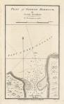
ARTIST: Joseph Bouchette
PUBLISHER: Published by William Faden, London.
MEDIUM: Copper engraving,
DATE: 1815
EDITION SIZE: 8 5/8 x 9 7/8" (220 x 250mm).
DESCRIPTION: From Bouchette's "A Topographical Description of the Province of Lower Canada." Engraved by J. Walker. A detailed chart, with soundings, showing the area from Kingston past Forest and Grand Islands into Lake Ontario.
ADDITIONAL INFO:
CONDITION: Good condition; black and white.
REFERENCE:


 Login / Register
 Basket