Price: $295.00
SKU: 47539
ARTIST: Fielding Lucas, Jr.
PUBLISHER: Published by H C. Carey & I. Lea, Philadelphia.
MEDIUM: Handcolored copper plate engraving,
DATE: 1822 (1823).
EDITION SIZE: 16 1/2 x 20 1/2" (420 x 518 mm) including text.
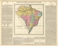
DESCRIPTION: This map, "Geographical, Statistical, and Historical Map of Jamaica", by Fielding Lucas Jr., 1822 (published 1823). Carey & Lea's A Complete Historical, Chronological, and Geographical American Atlas. This richly detailed map of Jamaica combines visual cartography with an in-depth written account of the island’s early 19th-century life. Alongside the map, the text offers a “historical sketch” and covers everything from boundaries, rivers, and climate to mines, civil divisions, population, major towns, commerce, transportation, religion, and government—making it as informative as it is engaging. Created during a time when Jamaica was a key hub of the British colonial economy, the map reflects the island’s strategic importance in trade and its role within the transatlantic world. It captures not just geography, but the rhythms of daily life and governance in a colony shaped by sugar, shipping, and trade. An exceptional example of early American atlas-making, both educational and compelling for collectors and historians alike.
ADDITIONAL INFO: This piece is in a 18 x 22.5 inch archival mylar for handling.
CONDITION: Good condition. Some soft staining in the upper corners. Short tear in lower margin, just into text. Original hand coloring.
REFERENCE:


 Login / Register
 Basket


![Geographical, Statistical, and Historical Map of the United Provinces of South America. [Argentina]](https://oldprintshop.com/uploads/2025/10/23531.jpg)