Price: $485.00
SKU: 47695
ARTIST: Nicolas de Fer
MEDIUM: Copper engraving,
DATE: 1705 (1741).
EDITION SIZE: 8 3/4 x 13 1/8" (22.1 x 33.2 cm).
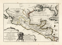
DESCRIPTION: This map, "Les Isles de l'Amerique Connues Sous le Nom d'Antilles" by Nicolas de Fer, published in 1705, spans from Yucatan and southern Florida to the Leeward Islands. It intricately details coastal features and towns, capturing the geographical breadth of the region. <br><br> Each island is marked with legends about its discovery by Columbus, and many are distinctly assigned to European powers, showcasing the colonial influences and territorial claims of the era. <br><br> This depiction not only serves as a navigational aid but also as a vivid historical document, illustrating the exploration and European competition in the West Indies during the early 18th century. The map's rich detail and historical annotations make it both a valuable educational tool and a fascinating collectible, perfect for enthusiasts of cartography and colonial history.
ADDITIONAL INFO: This piece is in a 10.5 x 16.25 inch archival mylar for handling.
CONDITION: Fine condition. Black and white.
REFERENCE: Phillips, Atlases, 546.


 Login / Register
 Basket