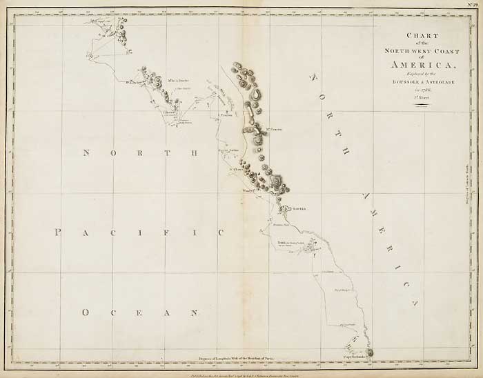
ARTIST: Jean Francois Galoup La Perouse
PUBLISHER: Published by G. G. & J. Robinson, Paternoster Row, London.
MEDIUM: Engraving,
DATE: 1798
EDITION SIZE: Image size 15 x 19 5/8" (384 x 498 mm).
DESCRIPTION: This chart shows the coast line from Cape Redondo (Tillamook Head, Washington) to Bay de Clonard (Graham Island, one of the Queen Charlotte Islands). La Perouse was selected by King Louis XVI to complete Captain James Cook's exploration of the western Pacific. Jean-Francois de Galaup & Comte de La Perouse commanded a French scientific expedition which set sail from France in 1785. The Boussole & Astrolabe with all aboard was shipwrecked in 1788 but the narrative, maps, and views survived and were published in 1797. La Perouse explored the coasts of the Gulf of Alaska and northwestern North America in search of the fabled Northwest Passage. After leaving America his expedition continued across the Pacific to Asia. This plate is from the English edition that was published by G. G. & J. Robinson in 1798.
ADDITIONAL INFO:
CONDITION: Good condition save for some occasional minor foxing. Black & white.
REFERENCE:


 Login / Register
 Basket
![Plan of the Port S. Diego in California ... from a Survey in 1782 [on sheet with] Plan of the Port & Department of S. Blas ... from a Survey in November 1777.](https://oldprintshop.com/uploads/jpg/56240_productthumb.jpg)