Price: $265.00
SKU: 56784
ARTIST: Joseph Meyer
PUBLISHER: Published by the Bibliographischen Instituts zu Hildburghausen.
MEDIUM: Engraving , hand colored,
DATE: 1846
EDITION SIZE: Image size 14 3/4 x 11 5/8" (373 x 295 mm).
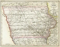
DESCRIPTION: Plate No. 99 from Meyer's Handatlas. A detailed German map of these two states, with a table listing counties and their seats at upper rght.
ADDITIONAL INFO:
CONDITION: Good condition with original color.
REFERENCE:


 Login / Register
 Basket