Price: $295.00
SKU: 56861
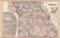
ARTIST: Ormando Gray
PUBLISHER: Published by Stedman, Brown & Lyon, Philadelphia.
MEDIUM: Stone engraving, hand colored,
DATE: 1873
EDITION SIZE: Image size 11 7/8 x 16 3/8" (300 x 406 mm).
DESCRIPTION: From "Gray's Atlas of the United States." An attractive map of North Carolina, colored by county borders. Includes topographic detail, roads, railroad routes, rivers, and canals. With an inset map of Beaufort Harbor in lower right.
ADDITIONAL INFO:
CONDITION: Good condition and color.
REFERENCE:


 Login / Register
 Basket