Price: SOLD
SKU: 47604
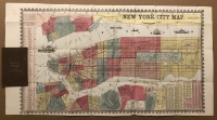
ARTIST: Humphrey Phelps
PUBLISHER: Published by H. Phelps, New York.
MEDIUM: Stone engraving,
DATE: 1857,
EDITION SIZE: Image size 15 1/4 x 27 3/4" (39 x 70..6 cm) plus decorative borders.
DESCRIPTION: An attractive early guide map of the city. The map is hand colored by ward and somewhat detained. Keys identify streets, wards, fire districts and railroads. Surrounding Manhattan is Jersey City, Hoboken and Elysian Fields, just outside of Hoboken, which is believed to be the site of the first organized baseball game. On the lower edge is Brooklyn Heights, Dumbo, Vinegar Hill, Williamsburgh, Greenpoint, Long Island City and a small portion of Astoria. Also shows early ferry routes between Manhattan, Long Island and New Jersey.
ADDITIONAL INFO:
CONDITION: Good condition save for close trimming along decorative border. Often this map if found this way due to binding. Original hand coloring.
REFERENCE:


 Login / Register
 Basket
")